Iceland: Exploring Fire and Ice
Well, I did it. Recently, I took a huge leap of faith into a world of unknowns. I did something a little crazy, something I had always dreamed of but never imagined would actually happen. On August 7th, I hopped on a plane to Reykjavik, Iceland by myself for the first time.
My journey to this isolated part of the world actually began with The GREEN Program. The GREEN Program provides short, intense, and hands-on educational programs on global renewable energy. My program took students to Iceland for 10 days to learn about the country’s innovative use of renewable energy and sustainability. It was by far one of the top experiences of my life and I would do it again in a heartbeat. I am grateful to The GREEN Program for the opportunity of a lifetime.
So with that, I hope you learn a little bit about Iceland, geology, and renewable energy from the following posts about my trip.
In order to keep this less than a novel, I included limited photos. To see more, go to the ‘Photo Album’ tab at the top menu. A special thanks and photo credit goes to all my fellow GREEN team members, especially Andie Biggs, Sarah Collmus, Emma Menio, and Stephanie Ly.
DAY 1: Reykjavik
On August 8th, I arrived in the northern most capital of the world. It was 6:30 am, I was exhausted yet wide-eyed and excited. Backpack, hiking boots, sleeping bag, ski jacket, fleece sweatshirt, and a massive piece of luggage in hand, I (not so) gracefully piled onto a bus that would take me to Reykjavik after an hour ride. That’s when it hit me. I am in ICELAND. By myself. To explore.
My eyes were glued to the window the entire time. And I may or may not have given a mini-geology lesson to two American boys behind me discussing the unusual landscape with dark hummocky plains along the peninsula and glacially carved mountains in the distance. When I arrived in the city, at my hostel, Kex, I dropped my luggage and went off to explore! Reykjavik is a really interesting city. Parts of it look really run down, while other parts are building up and have very beautiful, modern architecture. It’s a very colorful city with a rich history and lively culture.
Interestingly, Iceland’s tourism is a recent venture rising up within the past 7 years. The excitement of active volcanoes and earthquakes apparently draws more people than just geologists! Rocks are cool. Today, the tourism revenue exceeds the country’s revenue from fishing. That’s pretty incredible for a country that wasn’t even recognized on the map 10 years ago!
While not much geology was to be had on Day 1, I had an incredible time learning about the history and culture of such an isolated society. However, geology plays such an important role in the life of Icelanders that it has even influenced some of their architecture. Hallgrímskirkja, the iconic Lutheran church in Reykjavik, is modeled to look like beautiful basalt columns, a volcanic rock feature.


_edited")


Day 2: South Iceland
A third of my pictures were taken on this day. This is where the geology happens, and I nerd out a bit. I decided to take a tour to Southern Iceland and the Jökulsárlón glacial lagoon. Bridget, another student on the GREEN program who came to Iceland early, was crazy enough to come with me on this 13 hour tour after knowing me for only 4 hours. Seeing as how the tour was mostly retired folks, I was thankful for her and the long talks we got to share. And she let me talk about geology the entire bus ride.
The minute you drive out of Reykjavik, lush green plains covered in moss open wide with magnificent, craggy mountains along the horizon. There’s not many trees in Iceland, rather there are three types of moss that cover practically everything. The most vibrant green colors my eyes have seen. The government introduce lupine recently to help prevent soil erosion, which adds a nice touch of purple to the landscape. The plains are often times hummocky. These cryogenic earth hummocks form in fine grained soil with light vegetation and low relief, much like the fine glacial sand and ash along Iceland’s coast. These are cold climate land forms that occur in regions of permafrost or seasonally frozen ground. The flat lying coast provides adequate moisture to fuel the cryogenic processes.
Iceland is predominantly formed from layers of lava flows, or dried lava that came from deep within to the surface of the earth through a volcanic eruption or a crack in the Earth’s surface. That means most of the rocks, cliff features, and mountains are made of igneous (volcanic) rocks formed from the cooling and drying of molten lava. Despite the entire country being formed by one rock type (igneous rocks), a lot of variety can occur within that rock type depending on the chemical composition of the particular lava flow and cooling history. In fact, much of the country is still covered with active volcanoes, which will produce new lava flow layers when they erupt. We drove past one lava field that was made by one volcanic eruption that lasted 7 years!
Because of the location of Iceland, hot springs are very common. Among the green plains that rise into dark black cliff faces and mountains, steam stacks from hot water coming to the surface whisp into the atmosphere. They are everywhere! It’s really a different sight to see.


Iceland is a land of fire with volcanoes and hot springs and fissures in the surface, but what about the “ice” part in Iceland? It is true that the vikings named Iceland to keep other settlers and enemies away from the lush lands and lure them to Greenland where conditions are nearly uninhabitable. But, Iceland does contain ice and snow and glaciers as well. Much of the landscape has been sculpted by the moving and melting of glaciers over millions of years. And guess what? You can see evidence of those melted glaciers and how they changed the land today. For instance, when a glacier moves, it erodes away the rock below it. Unlike a river, which erodes a concentrated line creating a V-shaped valley, glaciers wipe away everything in their path creating a U-shaped valley instead. And this is why Iceland has such a unique landscape; it’s a combination of the fire and the ice that create immense beauty.
Glaciers in Iceland are no shortage–they’re around every corner it seems. So vast and magnificent among the dark mountains and vivid green hills. Our tour went to visit the Jökulsárlón glacial lagoon in southeast Iceland. The lagoon is at the head of Vatnajökull, the largest glacier in Iceland and second largest in Europe. The glacier covers roughly 8% of the country, 8,100 square km. Jökulsárlón glacial lagoon has formed in the last 80 years as the glacier has been retreating (melting away) from the Atlantic Ocean. At one time the glacier flowed right into the ocean, and now the lagoon carries large ice bergs out into the Atlantic Ocean. It is an indescribable, humbling experience to see the glacier from afar as we drove up to it. Forget about trying describe the feelings that come with standing next to the giant icebergs that have fallen off and float their way into the Atlantic Ocean. While this is one of the most beautiful places I have ever seen, this is an effect of Global Warming. At the rate the glacier is retreating, it will become a deep fjord where the lagoon is now in the near future. Although we can’t stop Global Warming from happening, we can fight to delay and weaken it’s effects on our Earth.


Day 3: The GREEN Program
The Earth is not going to change to sustain humans, so we must change our ways to sustain the planet we depend on.
Today I started The GREEN Program. What is The GREEN Program? It’s the experience of a lifetime.
Let me explain more. My only regret in college was not studying abroad. So when I was emailed about The GREEN Program and asked to spread the word at school, the first thought that popped into my head was: well, I want to go! The GREEN Program is headquartered in Philadelphia and is a short-term study abroad-internship program. That means that students get to go to a specific location to enhance their education and career experience with renewable energy and sustainability through a few classes, a capstone project, hands-on learning experiences, tours of power plants, and ultimate adventures. For someone who was too busy or gave up study abroad for an internship, this opportunity was perfect. I learned about green energy in a leading country from leading professors, got to visit and tour renewable energy power plants, and built up leadership and teamwork skills. I think by the end of this, you may want to apply to the program too!
Driving from the airport to our first stop, the landscape looked like we were on Mars; no joke, it was the weirdest terrain I have ever seen. The first stop of the day was to The Bridge Between Continents on Reykjanes Peninsula. As I mentioned, Iceland has a unique geologic location: it is split by the Mid-Atlantic Ridge. What does that mean? Well, in simple terms, it is where the tectonic plates (large slabs of the Earth) are spreading apart gradually over time allowing magma to rise from deep within the Earth, surface as lava, and cool to form new crust. The Bridge is between the Eurasian and North American plates, and passes over a major fissure (linear fractures created as the plates move apart) which provides evidence of a diverging plate margin. It was incredible to stand in between the two plates!


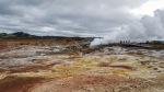
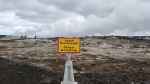
The next stop on the Reykjanes peninsula is called Gunnuhver where we saw mud pools and steam vents. The mud pools form where steam from boiling geothermal water (extremely hot water heated within the Earth) emanates and mixed with surface water. The accompanying gases such a carbon dioxide and hydrogen sulfide make the water acidic which alters the fresh lava rock to clay. The colors from the minerals and chemical reactions are spectacular yellows and oranges. When you walk near the vents along the pathway, you can see the boiling water, and you get splashed with a lovely scented geothermal water mist. The mud pools are named Gunnuhver after a female ghost that was laid to rest in the area. She had caused great disturbance until a priest set a trap for her and she fell into the hot spring about 400 years ago.


Continuing along the peninsula, we went to the coast where the ice cold ocean crashed below us among the volcanic cliffs on which we stood. Volcanic rock pillars protrude out of the sea. Near by on a hill stands Iceland’s first lighthouse, built in 1778. The views of the cliffs and hills and ocean were spectacular! Ten miles off the coast is a island named Eldey, or The Fire Island. The basalt rock island stands 77m tall in the middle of the ocean and glistens brightly from afar due to the over 16,000 (white) birds that live there. Eldey is not open to tourists in order to preserve the number of endangers birds that live on the island.


To end our first day on the program, we settled into our new home for the next few days: a quaint guesthouse on a farm in the mountains called Hjarðarból. Every morning and evening, we ate homemade meals in Helga’s Kitchen (part of the guesthouse where the owner cooks meals for guests). Talk about eating delicious local food!
Day 4: Hot springs
The GREEN Program has a way of keeping you on your toes at all times…you never know what you’re doing until the night before. Even at that, details are not dished out until you get there. But, no experience is an adventure without spontaneity, so I loved just going with the flow!
First thing in the morning, we drove back into Reykjavik where we had 3 lectures on renewable energy from different professors at the University of Reykjavik Iceland School of Energy. We learned about the history of Iceland, geothermal energy, and hydroelectric energy–all extremely fascinating lectures! The campus is really modern and beautiful, and the professors were very intelligible. The building itself uses renewable energy to power the electricity: the lights inside adjust to the amount of solar energy being generated at that moment.
After classes, we headed back into the mountains to a town called Hveragerði where we ate lunch at a geothermal kitchen, Kjöt & Kúnst. We had a choice of soups and the largest assortment of breads I’ve seen in my life (both an apparent staple in the Icelandic culture). On the outside of the building you can see some of the cooking appliances–the kitchen is power completely by geothermal power sourced right there. And the food was delicious!!


After lunch we took a hike to some hot springs called Reykjadalur. I did think it was going to be anything different that what I have experienced before. A hot spring is a hot spring, right? No, it was AMAZING! First of all, we had driven past these mountains a few times that I thought were just gorgeous. Well, we got to hike up into those mountains and see spectacular views along the way. Second, this was no little mud hole with warm water. We sat in a crystal clear river that was fed by both a natural cold river and a hot water stream, nestled in a valley surrounded by vibrant green mountains and pockets of orange and yellow craters with stream billowing out of the ground. The temperatures were just right to relax in for the afternoon. It was surreal and like nothing I have ever experienced.


Day 5: Iceland’s Renewable Energy Industry
Today we visited two power plants. First we visited Hellisheiði Power Station at the Hengill geothermal area. It is the second largest geothermal power station in the world and has a spectacular exhibit. We got to not only tour the exhibition, but went behind the scenes and got to see all the facilities and learn about the process in producing geothermal energy. The plant has a capacity of 303 MW of electricity and 400 MW of hot water. It was built to provide power for the city of Reykjavik, which has a growing demand. The power plant uses 500 kg/s of 356°F geothermal steam for the electrical production. The energy is extracted from 30 wells ranging 2000-3000 meters deep, which is then led through steam and mist separators before entering the turbines. The high pressure steam gathering system operates at 9 bar pressure, whereas the low pressure steam extracted from the steam separators is generated at a pressure of 2 bar. The electrical system of each unit is composed of a 50 MVA generator, a 50 MVA step-up transformer to 220 kV, an 11/11 kV transformer for connection to the 11 kV station service system and 11/0.4 kV transformers.
The Hengill volcano is composed of palagonite tuff (rock formed from consolidated ash) with its highest point reaching around 800 meters above sea level. The Hengill geothermal area is located in the middle of Iceland’s western volcanic zone, on the plate boundary between North America and European plates. The area is one of the most powerful geothermal areas in the world with several thousand of hot springs at the surface and a giant magma chamber hidden underground. It covers about 112 square km and constitutes one of the most extensive geothermal areas in Iceland. Although its most recent eruption was about 2,000 years ago, the Hengill volcano is still active.


The second power plant was a hydroelectric plant built in 1921 named Rafmagnsveita Reykjavíkur (Reykjavik Electrical Utility). While this plant was not the first hydroelectric power plant built in Iceland, it was the first municipal hydroelectric plant and could produce 1MW of power. This plant alone quadrupled the amount of electricity in the country. It is no longer used, but preserved in pristine condition and a landmark for Iceland’s incredible energy revolution in the world. In fact, Iceland is the first country in the world to create an economy generated through industries fueled by renewable energy. There is still a large amount of untapped hydroelectric energy in the country; in 2002 it was estimated that Iceland only uses 17% of the total harnessable hydroelectric energy in the country. Even so, the government believes that another 30 TWh of hydroelectric power can be generated every year while allowing some sources to remain untapped for environmental quality.


Where does this power come from? This island’s unique geology allows it to produce renewable energy cheaply and from a variety of sources. It’s position along the Mid-Atlantic Ridge makes Iceland one of the most tectonically active locations on Earth. The over 200 volcanoes and over 600 hot springs compose 20 high temperature steam fields that are at least 300°F or higher. This allows Iceland to harness geothermal energy, and the steam fields are used for everyday heating in houses and swimming pools. Glacial rivers and waterfalls are more than plentiful throughout the country, providing an easy source to harness hydroelectric energy.
In the afternoon, we went to a public pool called Laugardalslaug. It is an outdoor heated pool with a few hot tubs, a large pool with slides, and of course an ice pool in case the air isn’t cold enough.
That evening, we had our ‘night out’ in Reykjavik, which meant we rented a room in a hostel downtown, KEX, and had a good time with each other, ate delicious food (fresh cod), and enjoyed an eclectic bar with a great atmosphere. We played lots of team player games, and finally got the chance to really know some of the students. I even had to arm wrestle; I lost, but put up a good fight!

Day 6: Caving, Glacier Snorkeling, and Hiking
Today we didn’t go to class. Instead we went caving in a lava tube named Raufarhólshellir. It was alright, I guess.
Just kidding, it was INCREDIBLE! Talk about a geologist’s dream. As we pulled up, I could barely tell there was a big hole in the ground. We all bundled up in warm layers and rain gear with hard hats and headlamps; it’s a really attractive look. Then, we embarked on our adventure and entered the underground lava tube. The cave is about 10-30 m wide, up to 10 m tall, about 1360 m long (roughly a mile), and the roof is about 12m thick from the surface of the Earth. Raufarhólshellir is the fourth longest cave in Iceland.
The cave formed during the Leitahraun eruption about 4600 years ago. Lava tubes are a type of lava cave that form when a low-viscosity (runny, quickly moving) lava flow develops a continuous and hard crust, which thickens and cools to form a roof above the still-flowing lava stream.
The inside of the cave was very dark with large boulders of volcanic rock covering the ground. Ice formed sculptures on the ground.. It wasn’t exactly cold in the cave; it wasn’t warm either. It was wet, hence the rain gear. On the walls of the cave, striations or grooves were visible. I also noticed places the lava was dripping from the walls and cooled as drops on the surface.


We came to a big ‘room’ in the cave where we stopped, sat down, and took in the moment. We were the only ones that far into the cave. Not even animals live within the cave. Tinni, our guide, told us a legend of the cave as we sat in the quiet of this massive underground structure. During the time Magellan was exploring the world in the 16th century, he came to a place now known as the Strait of Magellan south of South America. While there, he found a tribe of natives, all except three of whom were killed by a disease. These three natives agreed to join and defend Magellan on his expedition, and in turn he promised to put their remains to rest in the most peaceful place on Earth. Although Magellan was killed en-route, his crew held up his promise and placed the remains somewhere in the Raufarhólshellir lava cave. To appreciate the power of the peacefulness in the cave, we sat in complete darkness and silence for at least five minutes, and I have to say, it was a moving experience. You couldn’t see a thing, and all that could be heard was the water dripping off the walls of the cave creating a beautiful nature song.
Bjarni, our other guide and professional vocalist, told us a ghost story. There once was a woman in Iceland who bore an illegitimate child. She was very poor and lived alone; she did not want the burden of a child and could not afford to support it, so she wrapped it in her nicest loin cloth and left it out in the snow. A few days later, she was invited to a nice party, but had nothing nice to wear. The baby reappeared and sang a song to the mother pleading her to take the loin cloth she wrapped the child in. There is a sorrowful song that goes with the ghost story. Bjarni sang this beautiful Icelandic song to us as we sat in the dark. It was an inexplicable, moving experience.
If that wasn’t enough excitement for one day, we spent the afternoon glacier snorkeling between the plates and hiking in Þingvellir National Park. Yes, part of Game of Thrones is filmed here. The park was founded in 1930, and holds cultural, historical and geologic significance. The park lies in a rift valley (created by the splitting apart of the Earth’s surface) that marks the crest of the Mid-Atlantic Ridge. The park includes the largest natural lake in Iceland, Þingvallavatn.
The entire park is covered in fissures, which are deep fractures in the Earth’s crust due to pulling apart of the plates. Every year, the plates drift about 2 cm further apart; this builds tension between the plates and the earth mass above. This tension is released through a major earthquake approximately every ten years. During these earthquakes, cracks and fissures are formed in Þingvellir. The Silfra (Silver) fissure is one of the largest cracks and rims Þingvallavatn Lake. The water in the fissure comes from Iceland’s second largest glacier Langjökull; the water trickles underground into porous lava rock where it takes 30 to 100 years to travel 50 km to the park. I tasted the water; it was so pure and sweet! We went glacier snorkeling in the Silfra fissure. This is the only place on Earth where you can swim between the continental plates. The water is about 35.6°F, so we wear dry suits over our clothes. Your face and hands are too numb to feel, and you hope that water does not seep in your suit through seams! The visibility of the fissure is 150-200m; it the Caribbean, a popular snorkel destination, visibility is at best 100m. There are no words for the beauty and magnificence of the fissure and experience…enjoy the pictures!


After snorkeling, we took a short hike to some waterfalls in the park. Along the way, we stopped at the sight where Alþingi, the Icelandic Parliament, was established in 930, and remained there until 1798. This is the oldest Parliament, in the world. The hike took us between the walls of the separating plates, which can be seen as giant, tall basalt walls towering on either side of the trail, parallel to the rift valley.
Day 7: The Golden Circle
The Golden Circle is a popular tourist route in Iceland. It’s name has nothing to do with anything geologic, but it’s a loop around 300 km of central and South Iceland showcasing spectacular geologic spots due the country’s position along the Mid-Atlantic Ridge and over a hot spot, a portion of the Earth’s surface which experiences volcanism as lava pushes up from under the mantle deep within the Earth.
Today we went and saw the Gullfoss (Golden Falls) waterfall and the geothermally active valley of Haukadalur, which contains the geyser named Geysir (real original). Gullfoss is a massive beautiful waterfall. Actually it consists of two waterfalls; the upper falls is 11 m and the lower one is 20 m. At the end of the Ice Age, great glacial floods carved out the gorge as the water forced its way through the cracks in the basalt lava layers. Hard layers of basalt form the edges of the waterfalls lying on top of softer sedimentary rock which is more easily carved out. The average water flow of the falls is 109 cubic meters per second, but it gets up to 2000 cubic meters per second when flood occurs. The Geysir we visited shoots up to 70 km, and has been inactive for several years at a time. Luckily the hot spring shot up every 15 minutes when we were there!


For lunch, we went to a family-owned greenhouse restaurant named Friðheimar where they use geothermally heated water to grow tomatoes and cucumbers year-round despite dark, cold winters. We got a tour of the greenhouse and explanation of what the growers do to harvest the crops. Then, we were served lunch in the green house with quaint table settings and delicious all you can eat homemade tomato soup, pickled cucumber salsa, and a variety of fresh breads. It is arguably one of the best meals of my life.


After lunch, we visited another hydroelectric power plant called Búrfellsvirkjun. It rests at the foot of the mountain, and is one of the biggest hydroelectric power stations in Iceland. It currently produces 270 MW. Several of the tubes as well as the main power station are lying in tunnels within the mountain. The symbols along the front of the power plant are Viking symbols, reflecting the rich culture in this area. Near the power plant, we stopped at a waterfall with crazy basalt columns. Basalt columns are natural features formed when lava cools and contracts, causing the rock to break into hexagonal shaped pillars. The direction the gases escaped out the end of the rock influences the position of the column (straight or bent).


And then the real adventure began. We switched buses to a “super bus” which is essential the top of a bus put on the bottom of a semi-truck. The wheels were the size of me. From there, we set out into the Highlands. I’ve seen a lot of mountains in my day, seen the Scottish Highlands, and practically grew up in the Tetons. I was not expecting to be blown away by these mountains, though they were spectacular from a distance. Yet again I was terribly wrong. Nothing will ever touch the magnificence or jaw-dropping beauty of the Icelandic Highlands. Imagine the most vibrant green color lining rugged, raw mountains jutting from sea level high into the sky. The bus drove over a very fine grained black sand (ash and glacially ground basalt rocks) on a non-existent road and through rivers. Everywhere I looked I could spot out at least 4 waterfalls. This place is hands down the most beautiful place I’ve been. After about an hour of driving into the heart of the highlands, we ended up in a valley where our campground was located, Basar hut in Þórsmörk (The Valley of Thor). There were a lot of people camping! Despite the rather chill temperatures and rain, August is a popular camping time for Icelanders. We grouped ourselves into tents and pitched up our bright blue homes for the next two nights.


Day 8: Camping and Hiking the Highlands
My tent woke up quite early compared to everyone else. When we opened the tent door, the sun streamed in, and seconds later I hear Saharra yelling to throw her a camera: a vibrant full rainbow shot across the sky over the green valley as the sun hit the sides of the mountains directly in front of us. It was a breathtaking sight that the three of us shared.

Today we took a hike through Þórsmörk. It was about 7 miles or so round trip. This is what I live for, so I was stoked, expecting something similar to Rocky Mountain hiking. Again, I underestimated the magnificence of the Icelandic Highlands. We first walked across the valley, which is glacially eroded. The ground is composed of dark fine grained sand with larger cobble size rocks on the surface. The glacier that once existed in this valley ground the basalt to a fine sand and the floods carried larger rocks with it. The valley had an anastomosing river running though it, which means that there were several smaller rivers and large rivers that make up the entire channel bed, and the rivers continuously move. For this reason, there were bridges with wheels that could be moved as hikers needed to cross the altering river channels. Then, we came to the bottom of the mountain with a healthy green forest of evergreens, which is not common in Iceland. The rest of the hike was absolutely stunning. We hiked past volcanic rock features carved by glaciers, saw several volcanic fields in the past, ate lunch at the ‘Troll Cathedral’ cave, drank fresh water from a stream, and climbed up glacially sculpted mountain sides to stand in awe of the most spectacular view I have ever seen. The pictures don’t do it justice. I officially deem this hike the best hike I’ve ever taken.


That night, the camp host invited us to a bonfire with songs and dancing. Icelanders do not joke about bonfires; it was massive. The old man camp host played the snare drum, there was a guitarist, and lots of people sat around the fire singing Icelandic songs. Of course our group beautifully sang a few songs for the crowd as well: pure entertainment for both sides. As the night grew darker and darker, we slowly retired to a blue tents for one more night in the wilderness. My heart swollen with happiness.


Day 9: Super Jeeps, Licking Glaciers, and Waterfalls
In the morning, our ride out of the Highlands awaited: SUPER Jeeps. Take you average jeep, van, etc, and put wheels with a 1 meter diameter on it, that’s what a super jeep is. We left the campground in style, needless to say. I got lucky and had a crazy driver, which meant we drove through rivers, raced the other jeeps, and drove over just about everything. Probably not the safest, but don’t tell my mom that.
We stopped at a typical Icelandic gorge called Stakkholtsgjá, which is a small canyon lined with a green carpet of moss and walls of basalt shooting straight up on either side. We crossed rivers, crawled up boulders, and ended up in a hidden little cove with a splendid little waterfall trickling down from way above our heads, making me feel so small. It would be so easy to get lost in the gorge, but I would have been perfectly okay with that!


Next stop: licking Gígjökull glacier. Gígjökull glcaier flows 1,666m don steep mountain slopes from a gap in Eyjafjallajökull’s (massive active volcano) crater towards the lowlands. We hiked down (and raced back up) very high glacier moraines to get to the glacier. Glacier moraines are mounds of unconsolidated soil and rock that have fallen onto the glacier as it melts or have been pushed along as the glacier moves. During the eruption of Eyjafjallajökull in 2010, a lagoon in front of the glacier filled with eruption material when the glacier outburst flood flowed at tremendous speeds (2,700 cubic meters per second), and therefore change the appearance of the glacier. The glacier is currently retreating, which means ablation of ice is greater than accumulation, so the accumulation area decreases, and the glacier shrinks. I got the experience of walking into the glacier where the water was flowing out, licking the glacier (accompanied with some dirt), and hiking around the glacially altered landscape to find some cool rocks.


After driving out of the Highlands, we took another short hike up a canyon at the foot of the Highlands. The canyon is called Nauthúsgil (“Canyon of Cattle Houses”), which lies under the Eyjafjallajökull volcano. The ravine is deep and very narrow, making it a fun hike! The Canyon is carved into tuff at the bottom (consolidated ash), with hackly jointed lava further up section and intersticial glacial lava at the top of the ridge. Rain and wind have eroded ravines and gullies through the less resistant tuff layer preserving jointed lava and pillow lava formations in certain areas. At the end of the ravine, there is a beautiful waterfall, but to get there you have to climb across wet, slick rock walls, hanging on to chains as you go up and across. Definitely on the adventurous side, but the view is so worth it!


After our Icelandic Super Jeep drivers cooked us classic hot dogs for lunch, we went to two more waterfalls: Gljúfrabúi and Seljalandsfoss.
Gljúfrabúi is a 40 meters high waterfall hidden behind a large cliff which gives it a mystical aura. It can be seen in all it’s splendor by wading the river through a narrow opening in the cliff or by climbing a steep path up the cliff and peering over the edge as you stand on a ladder. I did both; this waterfall is not your everyday waterfall sightseeing.
Seljalandsfoss drops 60 metres (200 ft) over the cliffs of the former coastline. From the loss of ice due to the end of the last Ice Age tens of thousands of years ago, the ice caps began melting off of Iceland. This meant the weight load on the island’s landmass decreased, causing the land to uplift, or rise. Later in history, the sea retreated and the shoreline followed, creating a distinct line between the Highlands with an uplifted ancient coastline and the lowlands that extend out to the modern coastline. The Seljalandsfoss waterfall is unique because there is a loop trail that allows tourists to hike behind the waterfall, which is an incredible experience.
Now entering the lowlands, we drove the super jeeps on the the black sand beaches along the coast. The sand is black due to the ground up basalt rocks from glaciers carried down my rivers and floods along with ash from the latest eruption. It’s a beautiful beach. Not far off the coast are the Westman Islands, which provide a picturesque view but are also known to be very beautiful on shore.


That evening, we stayed at new guesthouse located near the base of Eyjafjallajökull, in the country side with beautiful views of the Highlands. It is by far my favorite place we stayed because it was so peaceful and serene.


Day 10: Eyjafjallajökull and Glacier Hiking
Eyjafjallajökull is a volcano completely covered by an ice cap. It is 1,666 m tall (5465 ft) and has a crater about 2 miles in diameter. The south face of the volcano was once part of Iceland’s former Atlantic coastline, of which was uplifted creating cliffs while the sea has retreated about 3 miles. Eyjafjallajökull is part of an eruptive fissure system about 27 km in length fed by a magma chamber under the mountains derived from the Mid-Atlantic Ridge.
Based on the volcanic relics at the base of the mountain, scientists know that this volcano is old and its formation has been slow over the past millennia. Only four eruptions are known since the settlement of Iceland in the ninth century: 920, 1612, 1821-1823 when it caused a glacial lake outburst flood (massive flooding due to the melting of the glacier on top of the volcano), and three times in 2010. The most recent eruption in 2010 also caused a glacial outburst flood from Gígjökull. There was substantial ash fall that reached all the way to mainland Europe and caused over 104,000 flight cancellations. At the end of the eruption, the total volcanic material was equivalent to 180 million cubic meters of rock. We went to a visitors center for the volcano founded by farmers who live at the base of the volcano. Hearing about about the eruption first hand from people who experience it was incredible, but it was also fascinating to see and learn how it altered their lives and the landscape of South Iceland.


After a museum tour from the farmer family, we crossed the road an went to the Porvaldseyri Farm that was greatly affected by the eruption. Today, the farm is a self-sustaining farm that creates biodiesel from rapeseed oil. Biodiesel is an environmentally friendly fuel that produces less harmful emission. Rapeseed is grown on the farm, and is harvested to produce oil and biodiesel. Rapeseed oil (same as canola oil) produces 96% energy level and is harmless to the environment, whereas gasoline has a 90% energy level and is toxic to the environment (% energy level refers to how much energy can be produced from ~36 MJ/L). The owner let us taste the rapeseed oil and pellets (they’re gross) and then filled up the tank of our bus with the biodiesel.


For lunch we hiked up the stairs along Skógafoss waterfall and through a field of grass to a hill that overlooked the coast. Not a bad view while enjoying a traditional cucumber sandwich. Skógafoss is one of the biggest waterfalls in the country at 82 feet wide and a 200 ft drop. I had already been here at the beginning of my trip, but it was neat to walk up the 100+ over-sized steps to get to the top. Worth the view!


In the afternoon, we went for a casual hike on Sólheimajökull glacier located near the crater of the Katla volcano. It was a sunny, warm afternoon with no clouds-we really lucked out with perfect weather! We first had to take a 30 minute hike through a beautiful little valley to the glacier, then we laced on our intense crampons and were set to go! I’ve been on glaciers before, but this was different. It was more beautiful and getting to take a hike on the glacier was unreal. Solheimajokull glacier is an approximately 11-km-long outlet glacier which advances down a one to two km wide valley. The glacier falls from a height of about 1,300 m down to 100 m and, because of the location and shape of the glacier, it is sensitive to climate change. In fact, it has retreated about a kilometer in the last decade and the dirt trail down to the glacier has to be re-made every week because the glacier is changing so quickly. You can see the ground which the glacier used to cover now filled in with lagoons or composed of rough stony ground. You might be wondering now why allow people to hike on such a rapidly shrinking glacier–doesn’t it contribute to the melting? Walking on the ice does cause it to melt, but it is so minuscule compared to so many other factors, and walking on the glacier also helps wash away some of the ash, which is good for the glacier’s ‘health’.
Notice all the black color to the glacier? It’s not all dirt. The glacier contains a significant amount of ash from the last Eyjafjallajökull eruption. The black piles or mountains on the glacier are actually parts of the glacier that have not melted as quickly due to ash cover. Sólheimajökull glacier has a wonderful otherworldly landscape of ice ridges, frightful looking sinkholes and deep crevices, streams and waterfalls running across the ice, and lines of ash in the ice recording the abundance of volcanic eruptions in Iceland for the past millennia. On land, green shots of grass are sprouting to make the land a bit more pleasant. We drank out of a stream on the glacier; it was the purest tasting water I’ve ever had. As part of the GREEN Program tradition, we had a ceremonial moment and rubbed the ash mud from the glacier on each others faces in “Simba” style. Nothing will ever match the raw beauty and experience of Sólheimajökull glacier hike.


If you learn anything from this blog series, let it be this (as told to me by a tour guide): While the rest of the continents are shrinking, Iceland is actually growing. What factors into this? 1. As the tectonic plates spread at the Mid-Atlantic Ridge, new crust is produced new crust and expands the width of the island by 2 cm a year. 2. The activation of large volcanic systems in the past few years has enhanced the seismic activity of Iceland, which causes further spreading. For example, with Bárðarbunga, Iceland’s largest volcanic system, Iceland has become over 40 cm wider. 3. The ash and ground up basalt carried by eruptions and glacial outburst floods towards the ocean has significantly built up the coast. Soon enough, Iceland will take over the world.
Day 11: Capstone Projects
A major part of The GREEN Program is to complete a capstone project which is a project that involves identifying an information problem in a real-world setting and developing the means to address it using the material learned in a class setting. Obviously our projects were all focused on sustainability and renewable energy. These were group projects that we had been working on all week, and today we presented them to our peers and professors at the University of Reykjavik. Although I lived for all the adventure activities, working on and presenting our capstone projects was one of my favorite parts of the program. I learned more about renewable energy more than any class could have taught me. I’ve worked in groups and gained leadership through countless experiences and organizations, but the capstone project allowed me to utilize those skills in a ‘real-world’ setting while still refining those skills to help me become a better scientist and career woman. I was the only geoscientists and hard science person in my group, so I was the expert in that field which forced me to step up and be confident in my knowledge. I worked with engineers, bio-material engineers, and policy makers. Working with other specialists was the best part of the project. It created a unique group dynamic and made our capstone project very successful. For these reasons, I firmly believe that The GREEN Program is by far the best study abroad-internship program. Most study abroad programs don’t offer near the amount of variety, team building, and leadership while learning a new and unique subject matter.
The capstone projects included creating a world-wide online energy forum, an app that works with GoogleMaps to entice people to use greener transportation, using coffee-grounds in Seattle as a biodiesel fuel, and many other great innovative ideas. I chose my group because I was looking for a group that I could implement my passion for geoscience to improve the project. My group formed a consulting company called GreenEfficiency, LLC. that would help petroleum industries implement renewable energy into their company for a more sustainable future. Our slogan was “Turing black oil to green” by connecting industries to power the future. Our consulting company focused on using available resources to produce more efficient power without wasting revenue. Currently, oil and gas companies use 1/3 of what they produce to inturn generate energy during production. As part of our project, we chose Chevron as a case study company to utilize our services. We chose 3 Chevron localities (production facilities and rigs) to administer our company’s green energy initiatives by evaluating the average energy used on site, annual electric bill, the cost of renewable energy implementation and generation, and net cost of the entire operation. The three locations we chose and accompanying renewable energy resources are: 1. Blind Faith rig off shore New Orleans powered by offshore wind turbines (6 turbines) 2. Oil rig in West Texas in the Permian Basin powered by solar panels 3. Kern River Oil Production facility near Sonoma, CA powered by geothermal energy along the San Andreas Fault. It is important for GreenEfficiency, LLC. to work with o&g companies to integrate renewable energy and sustainability in a cost effective way that benefits the company financially, politically, and socially.


This was a really interesting project for me coming from Texas where I am surrounded by the petroleum industry, whereas the other members in my group had education paths directed for the renewable energy industry. By the end of the project, I think I helped convince them all that the petroleum industry is not a ‘bad guy’ and if we want to create a sustainable energy market, there needs to be a compromise between the non-renewable and renewable energy industries.
That night we went back to Hjarðarból and had a delicious last dinner together at Helga’s kitchen, complete with fresh cod and rhubarb custard.


Day 12: Last Day
Today was our last day together as a GREEN family. It’s surprising how you can take 30 people who have never met each other and are beyond awkward on the first day, and ten days later of constant interaction, we are crying over leaving and know possibly a little too much about each other than what is normally acceptable. These people are incredible businessmen, engineers, policy makers, and scientists that I have no doubt will become leaders in changing our world. It was a privilege being engrossed in their knowledge and having the experience of a lifetime with them.
Today, we explored around Reykjavik for a few hours. Tinni took us to the Handknitting Association of Iceland where there were endless rows of wool sweaters! I bought a beautiful wool wrap. When in Iceland…
Then, a group of us just wondered. It was really nice, just popping into random shops from book stores to thrift shops. For lunch, Bridget and I went to a really good farm to market type restaurant. Some of the GREEN members went to eat traditional Icelandic food: fermented shark, puffin, whale, and dried salmon jerky (I did try that)!
We walked to the Opera House, which is known for it’s architectural beauty modeled after the Aurora Borealis. It was very modern and a beautiful building inside. Then we sat along the waterfront near the port and watch boats come in and out–it was a gorgeous day out!


And then it came. It was time to leave. Some people were staying in Reykjavik a few days extra, while the rest of us said our goodbyes and were taken to the airport. I stocked up on duty free stuff in the airport (licorice and alcohol for Dad, aka the important stuff), then we were on our way. I was happy that I had 4 other GREEN members on my plane, and we all sat in the same row too! We flew over the coast of Iceland and I watched it pass by as I left a piece pf my heart behind. Later during the flight we flew over Greenland; what a spectacular sight! The mountains were very high and rugged, I could see lakes and valley filled with ice, and ice bergs were broken up and floating out into the ocean. There was zero evidence of life.
We landed in Toronto. As my friends picked up their luggage to be greeted by family, we said goodbye and I was left to finish the last leg of my trip home to Houston. For the first time in 12 days, I wasn’t with someone wearing the same GREEN Program t-shirt I was–I didn’t know what to do with myself! When I landed in Houston, the humidity and heat hit me like a wall of bricks as soon as I walked outside carrying a ski jacket, fleece, hiking boots, backpack, sleeping bag, and luggage. I was about to turn back around and by a ticket back to Reykjavik, but luckily Dad spotted me and welcomed me with a big bear hug.
Iceland was the adventure I never dreamed would happen, and I guarantee it won’t be my last.
What we are seeing is the rebirth of Earth, how the fresh, melted lava from deep inside the Earth is making its way to the surface. The creation of new land. It is a magnificent thing and wherever you look in Iceland you can see how the forces of nature have formed and shaped this country – and still are.
– Hjörtur Smárason, Raving Ravens
It’s incredible you got to venture out into a completely new place and quench the thirst of getting to get your hands dirty doing what you love. It’s hard to believe you were able to all of this in less than two weeks but it looks like it was worth every exhausting minute. People go their whole lives telling themselves “one day I’ll go here” but never seem to act on it. It’s more than admirable that you took a leap of faith and spent some time with people who get just as much joy from geoscience as you. Our planet lacks the appreciation it deserves with each generation but every so often we’re left in awe and forced to appreciate what we’ve been given. Towards the end of the blog, specifically at the word “Eyjafjallajökull,” I was fairly convinced you were just making some of these words up. Regardless, it was beautifully written and the pictures you took are absolutely incredible. Keep up the blog Emily, I really enjoyed reading it!
LikeLike
Emilie*
Excuse me, I just realized I spelled your name incorrectly!
LikeLike
Thank you, Sam, for your kind words and for reading through my post!
LikeLike